Pfast Pfiffner Traverse
The Pfiffner Traverse is a (nebulous) route connecting Milner Pass in Rocky Mountain National Park with Berthoud Pass at the tail end of the James Peak Wilderness, through a massive swathe of remote ridgelines, basins and trails. Of the few that have attempted or completed the link, opinions are strong on what the “best” or “ideal” route should or could be. A lot of that is simply because the route is so good. At any point you could easily argue you should be doing it differently, but how can one argue that “this trail is better than that ridge which is better than this high pass” when they are all so incredible? The reality is, however you slice it, you are guaranteed a grand adventure, incredible scenery, remote solitude and an enormous challenge.

For us, we wanted to do a “Pfast Pfiffner” traverse as a couple, unsupported. This meant optimizing the ~75 mile route for a single push with as light of a pack as we could manage.
We left Milner Pass around 5:30am, far away from our originally intended 4am start, but after realizing our headlamps would likely not make it through an early morning plus all nighter, we opted to wait until there was enough light to run sans headlamp. The gentle trail to Ida is an apt introduction to the miles to come. Alternating between hiking and running, the sun rises above the hard line of the continental divide, giving magnificent views of the nearby Never Summer range behind us and the distant Gore range in the distance.

Inkwell lakes in the morning light.
We continue over the summit of Ida without pause and dispose of the short traverse along Chief Cheley and Cracktop before dropping towards the Haynach Lakes basin. We pass some other trail runners at the lake, “looks like we both had the same route idea” they say — it’s possible, but quite unlikely. From here we pick up well maintained NPS trail, a highway in comparison to the talus and tundra alongside. From this trail we’re able to move with ease, passing through a huge herd of bugling elk near Sprague pass, making our way back up to the Divide at the Flattop Mountain junction.
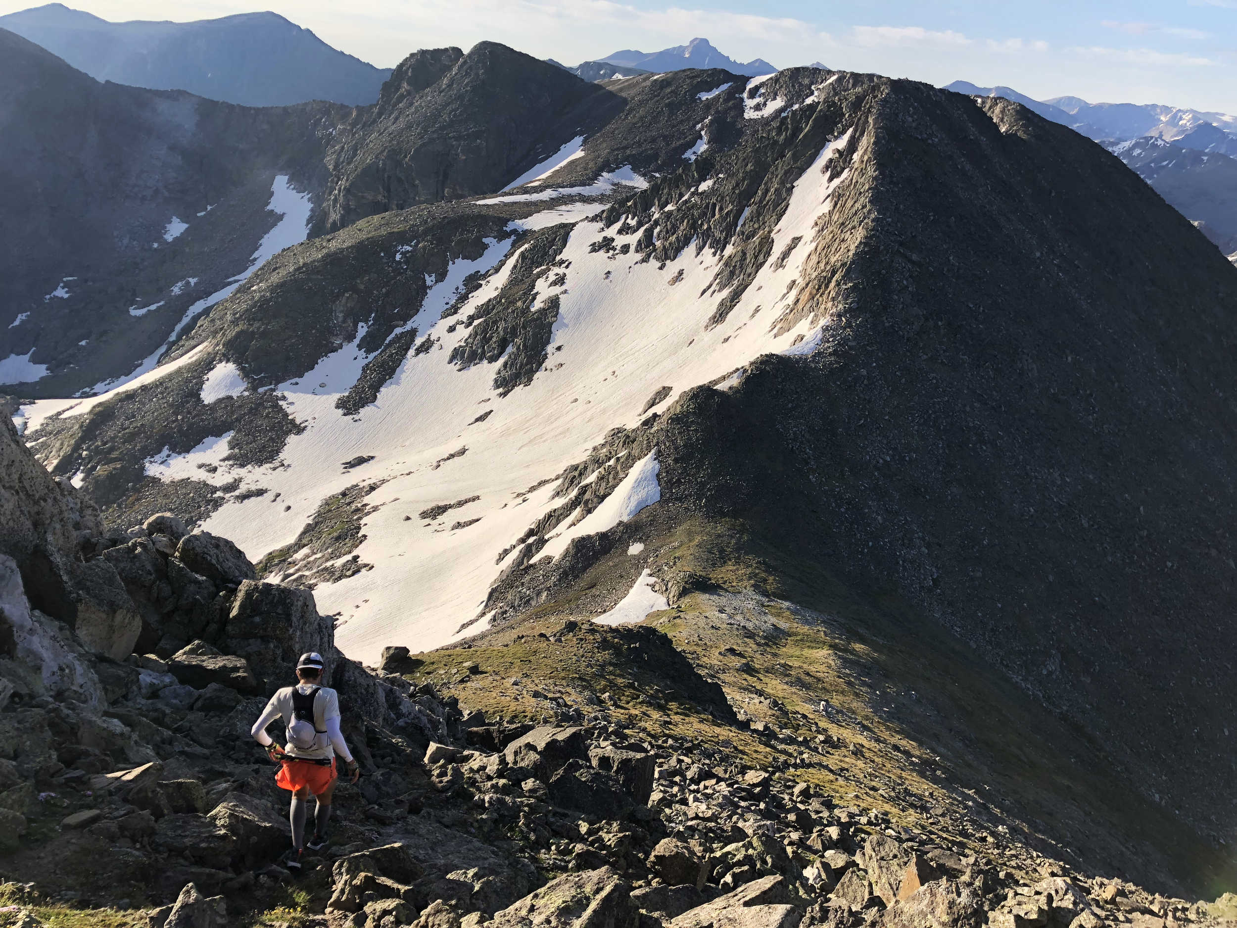
On our way to Chief Cheley and Cracktop
We continued on, descending the North Inlet trail down below treeline and taking descenders’ left up the Nokoni Lake trail. This trail, for some reason or another, we always find to be weirdly sleep inducing, even at 11am with a good night’s sleep. The switchbacks are spectacularly well-built and gentle in gradient, but just steep enough to not justify a run on this long of an effort. The lake itself made for a great first honest break where we took off packs, splashed some water on our faces, took a picture and each had a protein shake.
We felt hugely refreshed on the miniature bop of a pass to Lake Nanita just to the East. Lake Nanita marks the start of the true heart of Pfiffner as you enter the practically vacant Northwest corner of RMNP where the trails are long, overgrown and winding — when they’re there at all. A storm cloud was slowly creeping up the basin from Grand Lake and had us moving at a good clip beneath the Ptarmigan Towers, around Lake Nanita, over Andrew’s Pass and headed toward the shoulder off Mt Alice’s West ridge. The small basin before cresting Alice’s ridge is gorgeous little setting, full of enormous granite blocks before abruptly shifting into calm alpine meadows. As we felt the storm closing in on us, we found a luxurious enclave formed by a couple of boulders where we waited ten minutes for the rain to pass.

Not bad for a shelter on the fly!
When we gained the ridge above North Inlet, we were immediately greeted by the unmistakable scream of a fighter jet zipping down the valley and over Boulder-Grand Pass. Stunned, we heard another on its way, this time flying right down over the valley floor at maybe 10,500ft while approaching a 12,000ft pass. At the last second, the jet pulled straight up, gaining thousands of feet in just a couple seconds, and barrel rolled over the continental divide. An impressive display aerial power and elegance that we didn’t expect to see!
The descent down to Spirit Lake in the North Inlet drainage: it’s not terrible, but it’s a couple thousand feet at a moderate grade with enough deadfall to keep you on the edge of frustration. There is only a faint trail this deep into the basin which we intersect at the floor of the valley. North Inlet is full of incredible walls, if it was as short of a hike as Glacier Gorge I’m confident there would be a similar number of classic climbs. The feature which stands out to me the most is Aiguille de Fleur, which I still vow to climb one of these years.

Cresting the shoulder of Isolation Peak.
We take the path past the use trail for Boulder Grand Pass and up an even more faint trail towards the shelf of Fifth Lake. Sitting beneath the wildly complex west face of Isolation Peak, Fifth Lake is a worthy day trip on its own. It also, once again, marks our departure from trail for another large chunk of mileage. Four years ago, we slowly crawled our way onto the shoulder of Isolation as long shadows nipped at our heels. Today, we’ve got plenty of daylight remaining — and good thing, as we’re entering the most remote wilderness in the national park!
Cresting the shoulder of Isolation we were incredibly excited for the plunge into Paradise Park. Paradise Park is a designated research zone with no trails in or out and no camping allowed. The basin is a bit shrouded in mystery, so we’ve decided to keep with that. All we’ll say is that it is certainly worth the time, effort and distance to experience the area.

Paradise Park: a worthy detour from the divide.
We dropped into Hell Canyon from the Hiamovi-Ouzel saddle and were greeted with some waves from a group camped out on the other side of the pass. We contoured around the west side of the lake and stared down our final big pass we needed to get over before sunset. It’s a short pass over the Ooh La La - Cooper saddle, but a steep punch of 1200ft in just 0.7 miles. The pass was was almost entirely carpeted with wildflowers, save the last 30 feet. About a quarter way up, a squall came in with harsh winds and some sideways rain. The whole position felt quite epic, 30 miles deep into the wilderness and a steep slope of wildflowers looking down upon a gorgeous alpine lake. I crested the ridge first and found a practically windless shelter from the rain a couple feet down the other side.

The sprinkles begin as we head up the saddle between Ooh La La and Cooper, impossibly coated in wildflowers!
Abby joined a few minutes later and we were able to look upon one of the finest views on the route. The sun was finishing its days work casting an orange glow across Island Lake beneath us, backdropped by the jagged ridgelines which compose the heart of the Indian Peaks in the distance. The two lakes before us are quite significant as they mark the start of a long section of trail. Not getting onto the Gourd Lake trail by darkness (as we’ve done before) means significant bushwhacking in confusing terrain. In the light, there are plenty of ledges and grass gullies to follow, but when reduced to light by headlamp, this becomes a frustrating and confusing affair.

Island Lake, the notorious Gourd Lake shortly behind it. Indian Peaks brilliantly lit in the distance.
While we’re certainly not out to take our time, at the same time, there we are together at a gorgeous alpine lake with major sub-objective ticked off, so we take off our packs and take a seat by the lake for a bit to prepare for night, have some powdered meals and take in the surroundings.

Taking a moment before darkness sets in.
Once we stand and begin descending the gentle twelve switchbacks (of which maybe six are needed) down the Buchanan Pass trail it’s completely dark. Our last food stop isn’t sitting the best with Abby’s stomach, so we commit a brisk hike. We’ve learned that sometimes this is the best option, don’t stop and rest, don’t force a run, but constantly move and take care of yourself to keep you moving your fastest in the long run.
From Buchanan Pass, Abby and I prefer to stick to the original Fast Pfiffner route that Mark Oveson put together. Skurka’s variations through Paradise Park and Hell Canyon were awesome, but the route through the heart of the Indian Peaks in the dark didn’t align with our objectives of safety and fun for our adventure. Specifically, the Northeast Gully out of the Lone Eagle Cirque was still capped with an impassable cornice and the only other way I knew out of that drainage was the East Ridge of Achonee which felt mid-5th class in daylight and not something I’d want to take Abby to onsite at 2am. So instead, we opted for our night miles to take us down Cascade Creek to the junction with the Arapaho Pass trail.
The Arapaho Pass trail from Monarch Lake is very long and monotonous, never steep until the last few switchbacks to the Divide. We start our long march in good spirits just before midnight. We’re right on our forecasted schedule, with the next goal being to watch sunrise from the top of the pass. Between the tight walls of the Arapaho Creek drainage, the air is far colder than the forecasted mid 50F degrees we were expecting — that, or our long day’s effort is keeping us cold. We’d opted to forego down jackets to keep our packs light, but now we’re starting to regret going so light. We deploy our emergency blankets and with a bit of fine tuning, are soon merrily hiking along with flowing gold togas warming us like a foil wrapped burrito.

Chipotle, get at us.
Movement slows in the final hours of the night and as we gain altitude, we’re not certain we could withstand the even colder air of the pass without the warmth of sunlight. Around 4:30am we decide a quick 20 minute nap is in order to brighten our moods and allow for our post-treeline ascent to be greeted with twilight. Curling up on the side of the trail, it isn’t hard to fall asleep immediately, despite the terribly lumpy ground beneath us. When the alarm goes off, we promptly rise, not allowing a moment to contemplate how pleasant another, say, 8 hours of sleep would feel.
Light is just beginning to show in the sky and the excitement for the new day coupled with our power nap renews our spirits. Crossing the wetlands we see the silhouette of a moose running away behind a lake, perhaps fleeing the floating lights disturbing the otherwise still and dark morning. The final switchbacks to the pass have me more excited than Abby so I break away ahead, knowing there is a decently built shelter in the talus at the top. Finally cresting the Divide is a great feeling. I take a seat behind the rocks, put away my headlamp and gaze at the orange glow behind the jagged ridgelines framing Wheeler Basin. Abby joins me soon after and we can finally start to contemplate the simple but long walk along the Divide which remains.

The peachy moment of early dawn was the exact reward we needed after a cold night.
Another deviation from the original route that Mark took is Skurka’s suggestion of taking Caribou Pass to Columbine Lake, and then reascending to the divide via Neva’s West slope. Somewhat reluctantly we continue along this route. Caribou Pass and Columbine Lake amount to an extremely worthwhile detour, though the subsequent march around Neva’s slopes ends up being a rather nasty swim through talus and scree. We fill up on water, knowing this is our last fill up before the finish. In hindsight, I think I would have preferred getting Abby through Neva’s North Ridge instead, or perhaps a scenic route around Dorothy and Diamond lakes to Devils Thumb Pass or the East Ridge of Mt Jasper.
We press on, bypassing the grass summits on their western slopes, making a direct line towards the CDT which will provide fast and easier travel towards Berthoud Pass, which we can just now begin to see. Despite happily being on trail, the Continental Divide Trail is surprisingly technical on its way to Rollins Pass. The time passes neither quickly nor slowly. We move continuously, marching across the tundra.
From Rollins Pass the CDT is quite faint as it weaves its way towards Roger’s Pass beneath the mighty James Peak. Heads down in the wind, we feel like we’re making good time, we believe in ourselves and feel equipped to finally (on my third try, Abby’s second) complete the trek to the pavement of Berthoud Pass. Hiking along the edge of the Divide, we can’t not notice the black clouds looming above James Peak. We press on, trying to keep the weather out of our thoughts and hope that the systems clear.
Shortly before Rogers Pass, we regroup. We can’t ignore the storms circulating and building above the final high ridge walk to the finish. We can clearly see the road of Berthoud Pass, so close beyond. It feels wrong. We sit and watch wave after wave of clouds building in the Frasier valley and then moving over the ridge from James Peak to Berthoud Pass. It isn’t the worst storm we’ve ever seen. But if it weren’t for the meaning behind it, on a normal day we wouldn’t question turning around at all. But there we sit, 66 miles into our 75 mile traverse, with only 9 miles of grassy hiking standing between us and something we’ve dreamed of for the past four years. We sit there for a whole 45 minutes, debating, waiting and hoping. We turn on our phone, get service and check the forecast, which isn’t encouraging. The weather at this altitude is so unpredictable; surely this can’t last, surely this can’t be the end…
The thing we keep coming back to though, is that under any circumstances this wouldn’t even be a question. The fact is that we’re only even considering proceeding towards the storms we’re looking at because of what’s on the other side. Unfortunately, with time, we realize that the significance of the other side is beside the point. The mountains don’t care what we may or may not ‘deserve’, or that this is the one time we’ve gotten ourselves this far in sound condition and ready to continue. Reluctantly, we acknowledge that there is no debate on whether or not we should take the risk, the responsible choice is to acknowledge that to the mountains, we’re disposable. There is no inherent reason or meaning that will part the clouds and lift us to success. Knowing that made the pill a little easier to swallow.
At this point, we were able to sadly reverse course towards Rollins Pass where we could meet Abby’s parents for our bailout. Everything about the ending was quite disappointing. We missed our goal, but there it was in visual distance. Zooming out, we wanted an adventure that would challenge in ways we would not be by the races we would have otherwise been doing. In this case, we picked a long and unsupported navigation through some the wildest areas of our backyard. We also had the unique privilege of doing it as a couple which meant supporting one another and enjoying the entire trip more than we otherwise could have on our own or, really, with anybody else. I’m still in a bit of disbelief that the score of us versus Fast Pfiffner is 0-3, but I can’t imagine anything more fun to keep on trying at. Sure, we could have gone faster with a different approach, and maybe taken some further modifications to Mark’s original idea for more scenery. The reality is though, this was an outing born far more out of the joy of being together on an adventure, just the two of us, than any finish could have conveyed. Perhaps it’s a shame that that our DNF makes that still feel uncertain at times.
Will we be back? Who knows — I’ve said no to that question before and then gone back on my words. We’ll certainly draw upon this experience, the skills and confidence it developed and the fond memories for many, many years to come.